Affiliate links on Android Authority may earn us a commission. Learn more.
Waze vs Google Maps: Which navigation app leads the way?

Waze and Google Maps are two of the most popular navigation apps for getting from points A to B. Both apps are owned by Google, but they have unique features and abilities that set them apart. Depending on how you like to plan your trips and what kind of road conditions concern you, both apps have advantages over the other. Ready to compare the features and functionality of Google Maps vs Waze? Let’s get to it to decide which app is better suited for your navigation needs.
Waze vs Google Maps
Waze, founded in 2008 and acquired by Google in 2013, is known for its community-driven approach to navigation. The app relies on input from its users to provide real-time information about traffic, accidents, road closures, and other hazards. This information is then shared with other Waze users, allowing them to avoid congestion and reach their destinations more efficiently. In addition, Waze offers a range of features designed to make driving more fun, including customizable voices, points for reporting road conditions, and a social network that allows users to connect with each other.
On the other hand, Google Maps has been around since 2005 and is known for its extensive mapping capabilities. The app offers detailed satellite imagery, street-level views, and indoor maps of buildings like shopping centers and airports. In addition to its navigation features, Google Maps allows users to search for businesses and points of interest, read reviews, and even book reservations.
Waze and Google Maps have pros and cons, and the best app for you depends on your needs and preferences. So, let’s look at each app’s features and capabilities, comparing and contrasting them to help you decide which is right for you.
User Interface
Let’s start with the basics of each app’s appearance when you first open them. Regarding the user interface, both Waze and Google Maps are relatively easy to use, but they have slightly different layouts that can appeal to different types of people.
Waze has a more cartoonish and playful look, with bright colors and large icons. The home screen displays shortcuts to frequently used features, such as searching for a destination, playing music, or reporting traffic problems via the big yellow button. The settings menu, in general, is also easy to navigate, with different colored options.
With Waze, the menu opens from the left-hand side, where you’ll find your social profile at the top and recent and saved destinations below. Your profile shows a score for the impact you’ve had on other drivers based on the number of reports and replies you’ve contributed. We’ll discuss the specifics of reporting features later, but for now, know that Waze adds an element of gamification to commuting that makes you feel like you’re making a difference.
Google Maps has a more minimalist look, with a simple white background and smaller icons. Its home screen displays a map of the user’s current location with a blue icon that even shows the direction you’re facing. There’s with search and navigation buttons along the top and bottom screens.
Google Maps also has more layers for how you want to see the terrain, such as satellite view and street view, to see areas from a first-person perspective. The menu is accessible from your profile icon in the top right corner, but as you dig into the settings, they all tend to blur together with bland text on white background, which can be harder to find certain options.
Ads
Both Waze and Google Maps display ads, but they differ in how they do so. Waze shows sponsored pins on the map, which typically advertise nearby businesses. It also sometimes displays banner ads across the screen while navigating, which can be distracting. The ads disappear when you start moving again, but they pop back up every time you come to a stop.
Google Maps is a little more subtle with its ads. It displays sponsored pins as a slightly larger square icon rather than a circular pin on the map. It also shows ads in the overview of business pages and sometimes puts sponsored results at the top of search results.
There are no social or gamified elements to Google Maps when it comes to commuting, but some people don’t want to be bothered with that and want to get to where they need to go. Both apps are navigation services at their core, after all, so let’s examine how they compare on that front.
Navigation and Accuracy
Ultimately, both Google Maps and Waze will get you to your destination; they have different methods. With Google Maps, you punch in a location, and it will show you time estimates for a few different routes. With Waze, you input your destination, and it will follow the fastest possible way to get there. Both apps feature voice assistance for turn-by-turn navigation (but as you’ll discover in the last section, it’s a lot more fun with Waze).
The most significant advantage of Google Maps, however, is its broad support for a variety of methods of transportation. Whether you walk, cycle, or take the bus, Google Maps has the information you need. No matter where you are in the world, Google Maps features full timetables and routes for transit services and can integrate them into its directions without hesitation. It also has real-time updates on delays, such as busses running late, and even integrates with local ride-sharing services you can call within the app and, where available, nearby bike and e-scooter rentals.
Waze, on the other hand, is primarily designed for cars and motorcycles. That means no bus routes or bike paths are found on Waze. Although it does have a carpooling feature that allows users to share rides with other commuters.
If you do have a personal vehicle, Waze prioritizes speed over directness. Whereas Google Maps will tend to stick to main roads and single routes, Waze is more likely to take you off the beaten path if it means shaving a few minutes off your commute time. If you’re in a rush, you can rely on Waze to get you there the fastest way, as it constantly analyzes traffic conditions.
Regarding navigation accuracy, both Waze and Google Maps are generally reliable, but Waze does a better job of circumventing delays. Whereas Google might suggest an alternate route if traffic is getting really bad, Waze is constantly updating for what is the quickest possible way. The difference is because Google sources historical data and traffic sensors to predict the best route, whereas Waze is relying on active users on the road right now. Let’s take a closer look at how each app determines traffic information.
Traffic Information
Both Waze and Google Maps provide real-time traffic updates, with slight differences in how they display this information. Waze displays traffic information as colored lines on the map, with red indicating heavy traffic and green indicating clear roads. One advantage of Waze is that the app will show you the estimated speeds of vehicles. That way, you know how fast specific lanes are moving.
Because users can report things like accidents, road closures, and police checkpoints in real time, road conditions tend to be more up-to-date. For instance, I’ve had Google Maps tell me a road was closed off when it wasn’t because it was based on an old construction report submitted through city approvals. With Waze, if a person is there to see it open, they can report it as such on the app.
Google Maps is not all that different in its traffic data, but you do have to enable the traffic layer to see it. Traffic information appears as colored overlays on the map, with red indicating heavy traffic and yellow indicating slow traffic. There’s no speed information, however, since Maps relies on local authorities, traffic sensors, and historical data to predict conditions rather than depending on active user activity and reports.
Features and Abilities
Besides the turn-by-turn navigation and real-time traffic updates that Waze and Maps offer, there is more you can do with the apps. Let’s take a look at some key features.
Reporting
For starters, Waze has a few extra features that Google Maps doesn’t have. Namely, it focuses on community-driven features that allow users to share information about road closures, accidents, and police checkpoints. If you’re worried about red-light cameras or speed traps, Waze can alert you to their presence and see up-to-date gas prices nearby.
Google Maps also has a reporting feature, but it’s mainly for things like hazards and crashes. You won’t find police locations on Google Maps. On both apps, Whenever something like a hazard or impact is reported, nearby users will be notified and asked to confirm if it is still there. That way, as soon as it is cleared, that information can be updated on the map.
Trip planning
Depending on your means of transportation, Waze or Google Maps will be better suited to your needs. As mentioned earlier, Waze doesn’t have public transportation data, such as bus schedules or bike paths. When you are vacationing, or without a personal vehicle, Google Maps is much more reliable for finding the cheapest way to reach your destination.
But if you are driving, Waze does have a feature to plan your drives where you can input your destination and departure time, and the app will notify you when you should leave based on traffic conditions. It can be helpful to gauge when the busiest times are, and the app will notify you if conditions change until you depart.
Discovery
Because Google Maps has more users, it has a more extensive database of points of interest than Waze. Maps has a feature called Explore, which can show you nearby restaurants, bars, and other places of interest, with plenty of user reviews and pictures. You can easily browse a diverse set of feedback to help you decide on nearby destinations, which almost makes Google Maps a travel guide companion.
Waze’s discovery options are more limited. There is a category page tucked within the “Where to?” search bar, but the only real suggestions it will give you on the map itself are for gas stations. At least those do have up-to-date pricing from user reports.
Social networking
Waze users (or “Wazers”) can customize the appearance of their avatar and vehicle and see others on the map in real-time. The app also has a library of unique voices for navigation, featuring celebrities and characters from pop culture, and will even let you record your own voice to use.
The more you contribute to Waze, the more you level up as well. Reaching higher ranks earns you certain privileges, such as map editing rights for certain cities or regions. Google Maps customization options are rather limited, with only three vehicle options and voices for different languages and regions. If you want more options to express yourself, Waze is the way to go.
Regarding social engagement, Google Maps doesn’t offer points for commuting-related tasks but gives you rankings for reviewing restaurants and local businesses. With enough reviews under your belt, you can become a verified local guide for others.
Offline use
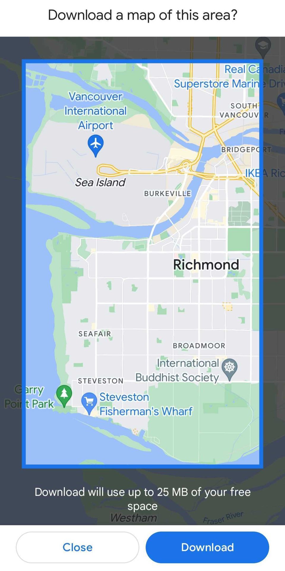
If you are going somewhere without service, Google Maps has more full offline maps for you. You can download entire maps for offline use in areas where you don’t have access to cellular data or Wi-Fi, which is helpful for traveling to places you haven’t been to before.

Waze is limited to saving individual routes to your favorites for offline use. The downside is that if you stray off course or take a wrong turn, Waze won’t save other areas of the map, as does Google. Either way, you won’t see the live road conditions while disconnected on either app.
Vehicle Integration
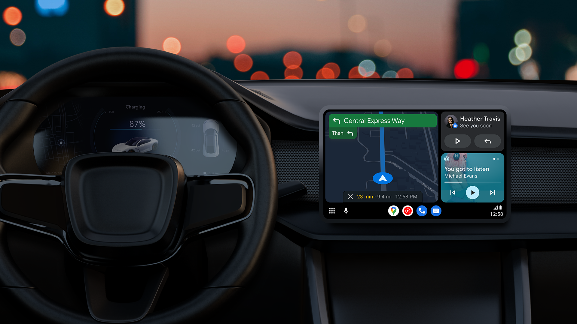
Regarding car integration, both Waze and Google Maps are available on Android Auto and Apple Car Play. Both platforms allow users to connect their smartphones to their car’s dashboard display for hands-free controls. However, Google Maps currently supports Android Auto’s new Coolock display, allowing users to access multiple apps simultaneously. Luckily, Coolwalk is on the way for Waze, but no hard release date has been set.

Both Waze and Google Maps are integrated with Google Assistant, which allows users to use voice commands to navigate or search for destinations. However, Google Maps has more extensive integration with Google services, allowing users to send messages, make calls, or access other Google services like Calendar.
Google Maps vs Waze: Which One is Right for You?
For users who prioritize accuracy and reliability in navigation, Google Maps is the better option. It has a more extensive database of routes and destinations and offers more features for exploring and discovering places, such as reviews and ratings, photos, and Street View. Google Maps is also more straightforward in terms of its interface, making it easier for users who don’t need a lot of additional features.
On the other hand, for users who want a more interactive and social experience while driving, Waze is the way to go. Its community-based approach provides more accurate and up-to-date information on traffic, accidents, and road hazards and the ability to share information with other users. Waze also has features such as unique voice navigators, personalized alerts, and a playful interface that can make driving more enjoyable.
Personally, I use Google Maps when traveling abroad because I usually take public transportation and like to look up recommendations for local restaurants or events. But when driving my car at home, I rely on Waze to find the fastest route through traffic and get a heads up on any hazards or speed traps. As such, both apps have use cases where one excels over the other, so I’d recommend trying out both to see which one suits your particular needs and preferences.
Which navigation app do you prefer, Google Maps vs Waze? Let us know in the comments below, and check out our favorite GPS and navigation apps for Android for even more options.
FAQs
]Waze and Google Maps have their unique features, making them both useful in different scenarios. Waze is known for its community-driven approach, providing real-time user-generated traffic and hazard information. This feature makes it more suitable for navigating areas with heavy traffic or frequent accidents. On the other hand, Google Maps has a more extensive mapping capability and integrates with other Google services such as Google Translate, Google Photos, and Google Assistant. It’s also suitable for exploring new areas or planning longer routes. Ultimately, which app is better depends on your preferences and specific needs.
Waze is known for its social features, such as allowing users to report accidents, police activity, and road closures in real-time. It offers more detailed traffic information, including seeing which lanes are moving faster. Waze has various customization options, from choosing your avatar and the navigation voice. Google Maps, on the other hand, is better for general directions and has a more straightforward interface. It also offers a wider range of features, such as public transportation options and the ability to search for businesses and view reviews.
Both Waze and Google Maps use similar technologies to provide precise navigation, including GPS and real-time traffic data. However, Waze relies more heavily on user-generated content to provide updates on traffic, accidents, and road closures, which can sometimes be less reliable. On the other hand, Google Maps uses a combination of algorithms and data from Google Street View to provide accurate information about traffic conditions and directions. Ultimately, both apps are generally reliable and accurate, but the level of accuracy can vary depending on factors such as location, network coverage, and user input.
Yes, Waze is generally better at finding the fastest way out of traffic than Google Maps. This is because Waze relies on active user reports determining traffic conditions and can estimate the average speed vehicles are traveling on roads. Google Maps relies on historical data to predict trends and traffic sensors from local authorities to determine traffic conditions.
Yes, you can use both Google Maps and Waze simultaneously on your phone. However, it’s important to note that running multiple navigation apps at once can drain your battery faster and may cause your phone to run slower.
Waze does use more data than Google Maps, as it relies on real-time updates from other users to provide information on road conditions and hazards. However, this data usage is typically minimal and should not significantly impact your mobile data plan.
Yes, Waze is owned by Google, and the company acquired it in 2013 for over a billion dollars.