Affiliate links on Android Authority may earn us a commission. Learn more.
Google Maps upgraded with higher-resolution satellite imagery and 45-degree aerial images

Today, Google has launched a few improvements to Google Maps, and these are by no means little things. First, Google has refreshed its Maps with higher-resolution aerial and satellite imagery, which means more places around the world can enjoy better images.
In particular, Google says their Maps and Earth apps have been updated with higher-resolution images for 17 cities and 112 countries or regions, which gives better deal of detail for these places.
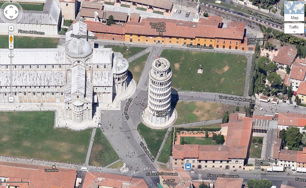
Also, 45° imagery is now available to 51 cities, which includes 37 U.S. locations and 41 international locations. With this view, you can take a virtual tour of supported locations as if you’re doing a fly-by. This is particularly great when you’re checking out the landscape or architectural works.
Here’s a complete list of places with improved Google Maps images:
Cities with new high resolution 45° imagery:
United States: Ames, IA; Anderson, IN; Billings, MT; Bloomington, IL; Carmel Valley, CA; Cedar Rapids, IA; Coeur d’Alene, ID; Corvallis, OR; Danville, IL; Dayton, OH; Detroit, MI; Dubuque, IA; Elizabethtown, KY; Enid, OK; Florence, SC; Grand Forks, ND; Great Falls, MT; Gulfport, MS; Hartford, CT; Kankakee, IL; Kenosha, WI; Lafayette, IN; Lancaster, CA; Lansing, MI; Lewiston, ID; Los Banos, CA; Madison, WI; Medford, OR; Michigan City, IN; Olympia, WA; Pocatello, ID; Sheboygan, WI; Sioux City, IA; Sioux Falls, SD; South Bend, IN; Terre Haute, IN; Utica, NY.International: Angers, France; Clermont-Ferrand, France; Coimbra, Portugal; Dijon, France; Grenoble, France; Livorno, Italy; Lyon, France; Newcastle, United Kingdom; Oberhausen, Germany; Palermo, Italy; Pisa, Italy; Toulouse, France; Troyes, France; Winnipeg, Canada.Areas with new high resolution aerial updates:
Florence OR, Kellogg ID, Casper WY, North Platte NE, Concordia KS, Alva OK, Austin TX, Nevada MO, Chilicothe MO, Toulouse FR, Clermont-Ferrand FR, Angers FR, Nantes FR, Troyes FR, Lille FR, Thun CH, Lucca ITAreas new high resolution satellite updates:
Canada, United States, Mexico, Cuba, Jamaica, Haiti, Dominican Republic, Guatemala, Honduras, Nicaragua, Costa Rica, Panama, Colombia, Venezuela, Brazil, Peru, Bolivia, Paraguay, Uruguay, Argentina, Antarctica, South Africa, Namibia, Botswana, Mozambique, Zimbabwe, Madagascar, Zambia, Angola, Malawi, Tanzania, Democratic Republic of the Congo, Kenya, Somalia, Ethiopia, South Sudan, Sudan, Uganda, Central African Republic, Nigeria, Cameroon, Chad, Niger, Benin, Ghana, Burkina Faso, Ivory Coast, Guinea, Sierra Leone, Mali, The Gambia, Senegal, Mauritania, Western Sahara, Morocco, Algeria, Tunisia, Libya, Egypt, Israel, Saudi Arabia, Yemen, Oman, Qatar, United Arab Emirates, Kuwait, Turkey, Iran, Ireland, Norway, Sweden, Portugal, Spain, France, Italy, Poland, Lithuania, Finland, Belarus, Ukraine, Moldova, Romania, Hungary, Austria, Croatia, Serbia, Bulgaria, Greece, Russia, Kazakhstan, Uzebekistan, Turkmenistan, China, Pakistan, India, Sri Lanka, Bangladesh, Thailand, Nepal, Bhutan, Myanmar, Laos, Vietnam, Korea, Japan, Mongolia, The Philippines, Malaysia, Indonesia, Australia, New Zealand
If you’re using an iPhone 5 or any other iDevice running iOS6, you can access these improvements by opening Google Maps on your mobile browser. If you’re using Android, then no additional settings or changs are necessary. Just be sure you’re in “Satellite” view so you can see better-resolution images and 45-degree views.
Google just released an underwater “Street View” feature earlier this week. We wonder what the Maps team has coming next.